
Andy and Mercedes Lilienthal drove a 2025 Subaru Crosstrek Wilderness 7,163 miles from the Atlantic to the Pacific on the TransAmerica Trail — 3,184 unpaved miles, 29 days, 39 reroutes, zero mechanical failures. A proof-of-concept for soft-roaders on the country's most demanding amateur overland rou
By Andy & Mercedes Lilienthal — September 2025
"The TransAmerica Trail might be the slowest, longest way to cross this country thanks to a mostly off-road route that rarely hits paved roads, much less a hotel with resort amenities." — Mercedes Lilienthal
We drove a 2025 Subaru Crosstrek Wilderness from the Atlantic Ocean to the Pacific Ocean on the TransAmerica Trail. It took us twenty-nine days, covered 7,163 miles, and included 3,184 miles of unpaved surface. The average speed for the whole trip was twenty-five miles per hour. We averaged eleven to twelve hours of driving a day. Our longest day behind the wheel was thirteen hours and forty minutes.
We never saw another TAT traveler the entire time.
This is the story of how a lightly modified AWD crossover — a vehicle that much of the off-road community still considers a "soft-roader" — handled the most demanding amateur overland route in the lower 48. It is also the story of what we learned about ourselves, about the country, and about the kind of overland trip most people never think is possible until they try it.
The Bet We Made in a New Jersey Parking Lot
The TransAmerica Trail was mapped by adventure motorcycle enthusiast Sam Correro, originally as a route for dual-sport bikes. It runs from Nags Head, North Carolina, on the Atlantic coast, to Port Orford, Oregon, on the Pacific — about half off-pavement, half badly-paved-and-dusty. The GPX files and paper roll charts are available through transamtrail.com. It is, by design, the slowest, hardest, most beautiful way to drive across America.
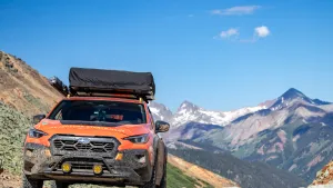
We picked up our Crosstrek Wilderness from Subaru of America in New Jersey. The plan was to drive it home to our starting point in Nags Head, immediately point it back west, and start the TAT proper. We had about a year of planning behind us, a vehicle with 9.3 inches of ground clearance, and roughly 212 TAT-specific miles per day to cover for the next month.
The first thing we did, before any of that, was admit out loud to each other what we were really doing. We were going to take a Subaru Crosstrek — a vehicle most people associate with a Target parking lot and a dog crate — into 3,000 miles of dirt, rocks, clay, river crossings, twelve-thousand-foot mountain passes, and weather so severe we'd end up rerouting thirty-nine separate times.
We had done enough long-distance work to know that the vehicle is only half the story. The other half is whether the two people in it are willing to be wrong in public, several times a day, for a month.
Building the Rig
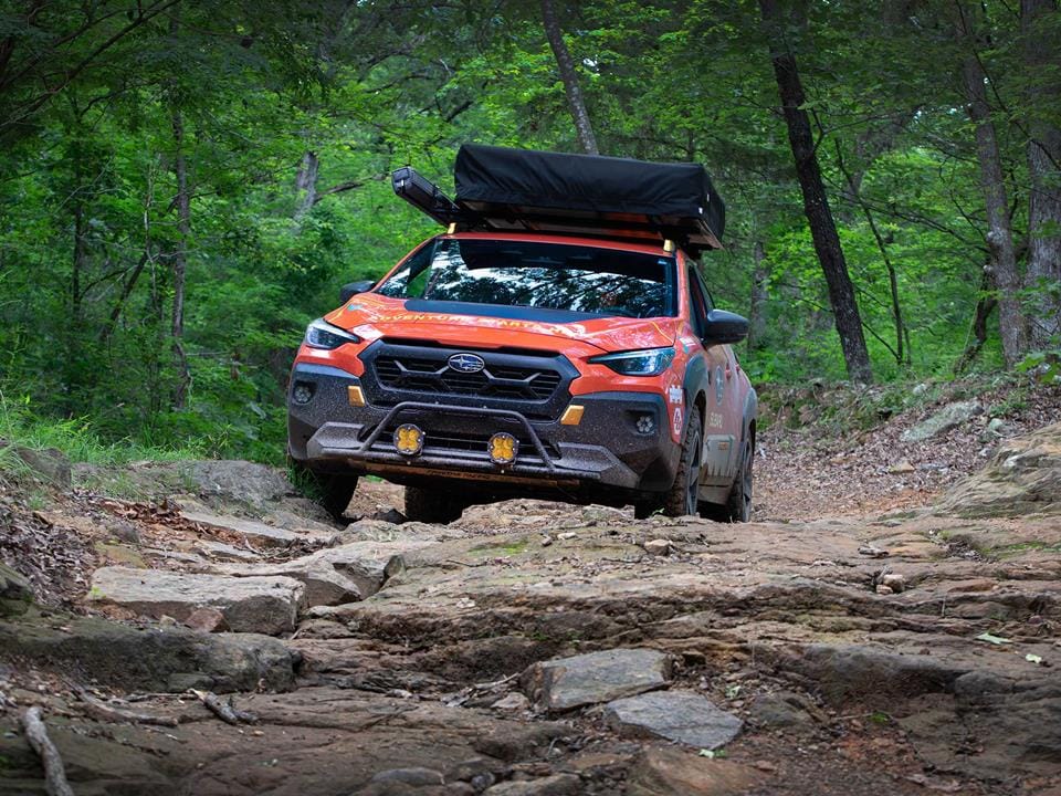
The stock Crosstrek Wilderness is a more serious piece of equipment than most people realize. The 9.3 inches of ground clearance is meaningfully better than a standard Crosstrek's 8.7. It has a version of Subaru's X-MODE that includes a Snow/Dirt setting and a Deep Snow/Mud setting. The 2.5-liter naturally aspirated boxer four is the same basic engine the company has been refining for a decade. The CVT is a known quantity, well-understood by tuners and mechanics from coast to coast.
We did not turn it into a Wrangler.
What we did add:
Armor:
A full Primitive Racing skid plate package — front, mid, and rear differential. The factory "skid plate" is a piece of plastic; it looks reassuring, it does almost nothing. The Primitive plates are the single most important modification we made and the reason we drove away from every rock garden we entered. We would buy these again without thinking.
Tires and wheels:
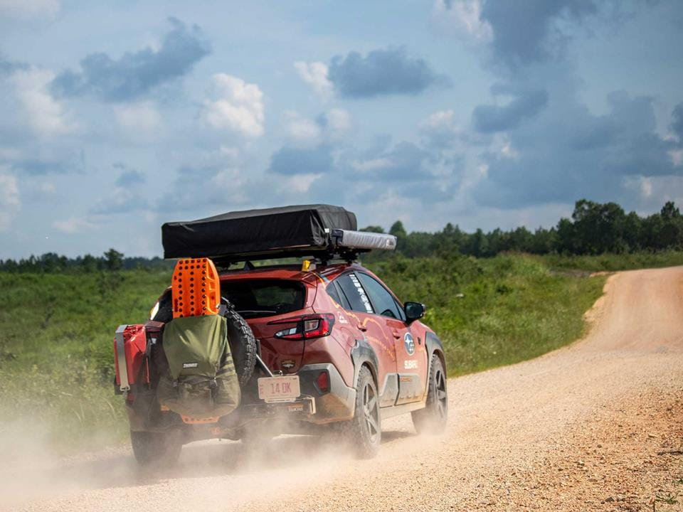
BFGoodrich All-Terrain KO2s in a slightly larger size, mounted on bronze Reika R15 Seeker wheels — 17x8, 5x114.3, +38 offset. The wider stance and the KO2 sidewalls gave us the aired-down contact patch we needed for sand, mud, and the long washboard sections of the central states.
Suspension:
Bilstein B6 struts up front, taller and stiffer King Springs in the rear acting as overload springs. In hindsight, we would have gone even more aggressive on the rear spring rate — fully loaded with a rooftop tent, an awning, a RiG'd Supply UltraSwing swing-out, drawers, fridge, and recovery gear, we were using most of our suspension travel on rough roads.
Power and comms:
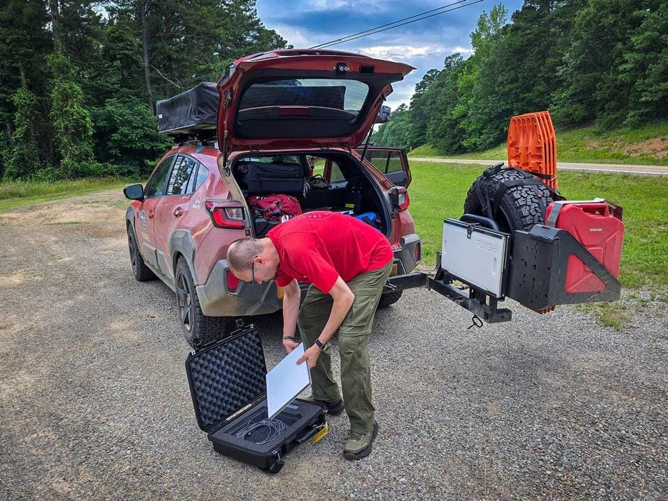
An EcoFlow DELTA 3 Plus portable power station, charged by an 800W alternator charger that runs off the engine bay while we drive. No solar needed. A Starlink Mini in a Pelican transport case for the days we absolutely needed to be reachable. A Garmin Tread Overland Edition for navigation, running the official TAT GPX files. A paper roll chart as the unbuggable backup.
Recovery:
A hitch-mounted rear recovery point, a kinetic recovery rope, soft shackles, heavy-duty gloves, and a set of MAXTRAX XTREME traction boards. We never once had to use the boards, but that was luck, not skill.
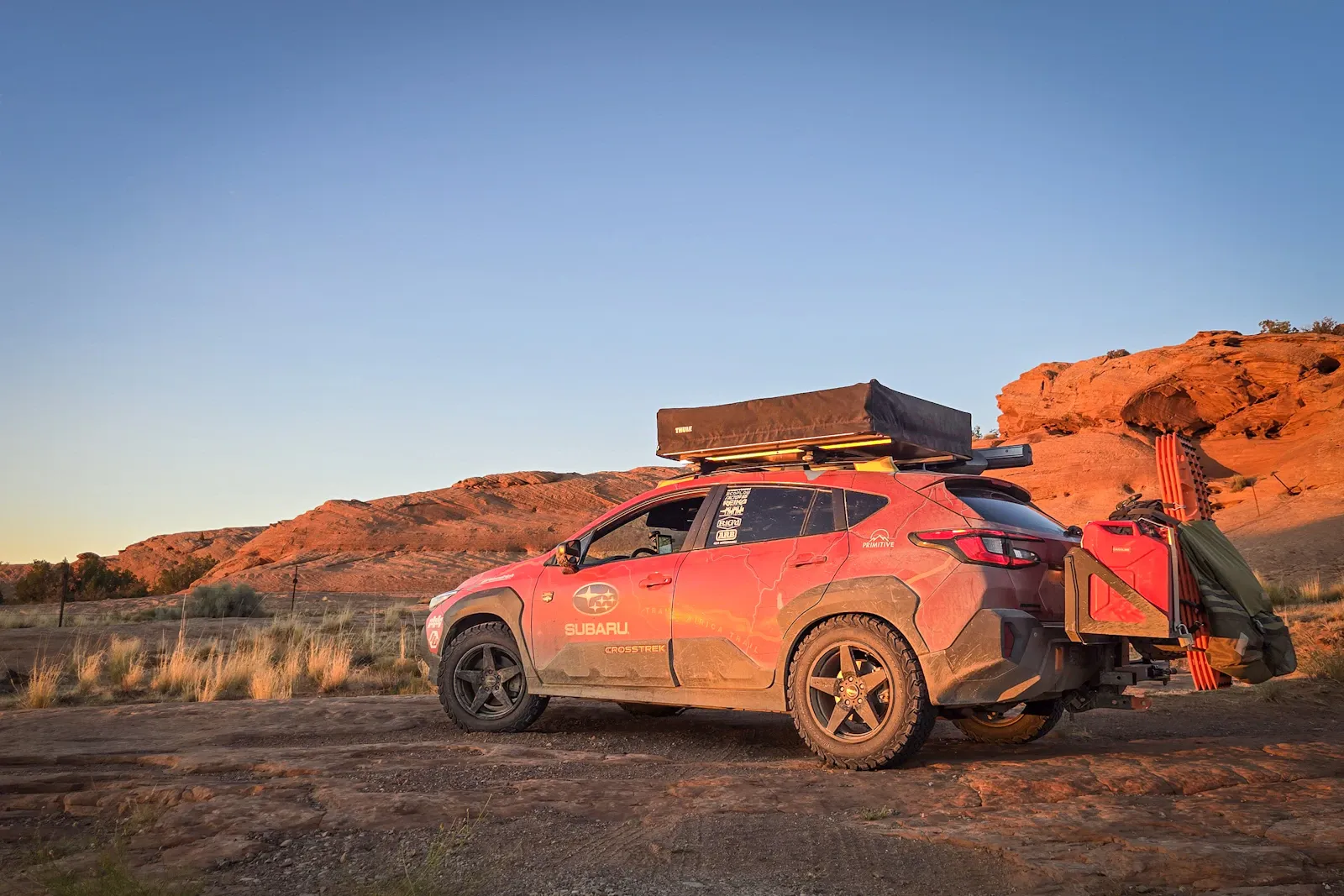
Sleep and storage:
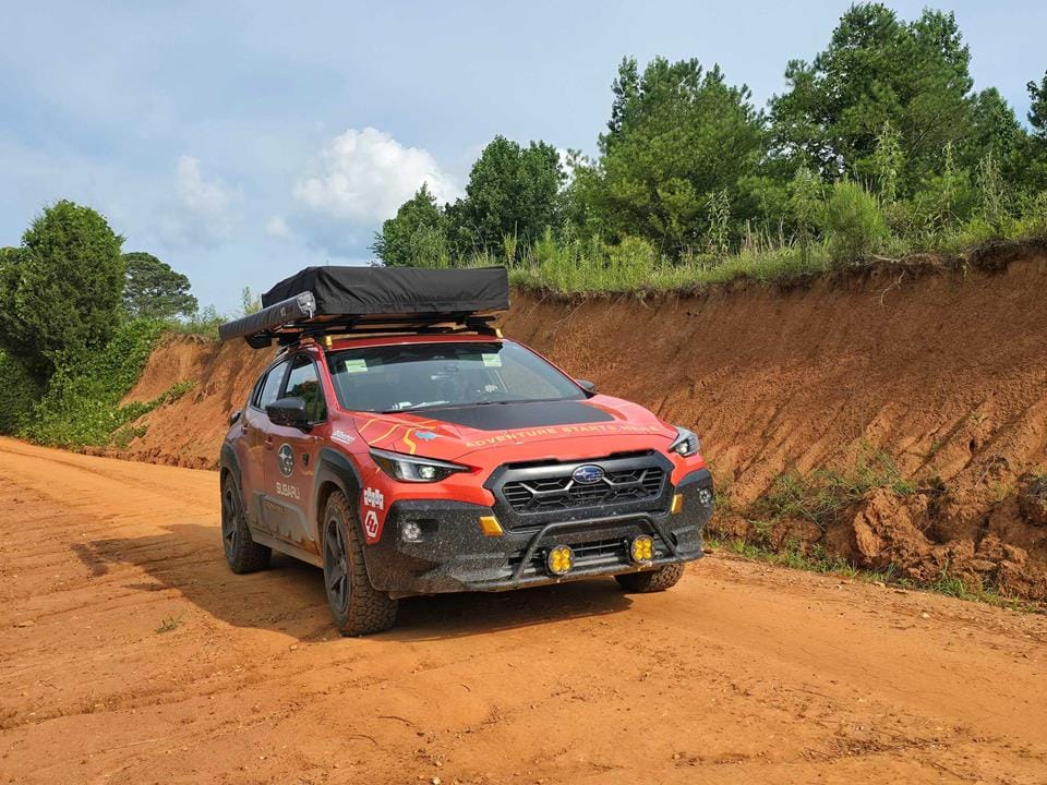
A Thule Approach rooftop tent — comfortable, weatherproof, and the reason we slept in places that don't have names. An ARB 50-quart Classic Series II fridge/freezer, controlled by phone, which Mercedes has publicly called her "lifeline." Baja Designs XL R Pro LED auxiliary lights on a Rally Innovations light bar mount for the dark forest roads and the long, unlit, dust-choked two-track sections of the western states.
The fully loaded vehicle came in at 3,999 pounds, against a gross vehicle weight rating of 4,817. That gave us 818 pounds of remaining payload, which sounds like a lot until you account for fuel, water, food, two humans, and a month of clothing. We were not at the limit, but we were at the brink of the limit, every single day.
Days 1–13: The Eastern Section
The TAT begins with a climb into the Smokies from the North Carolina coast, then turns west into Tennessee. We knew from the planning stage that this section had the worst weather of the trip. We did not know that "worst" would mean sustained temperatures over 90°F for 28 of the 29 days, with six of them above 100°F, and a storm track that parked itself over our exact route for the first two weeks.
On the second day, a storm system moving up from the Gulf dropped tennis-ball hail on our planned routing through the Ozark National Forest. We sat in a Motel 6 in Russellville, Arkansas, for two nights waiting for it to pass. It didn't really pass. It moved three counties east and chased us there. We sat in another motel in Clarksville, then another in Ozark. We burned five days of buffer and felt, in a way that is hard to describe, that the trip was already over.
It wasn't. But that was the first lesson: the slowest way to cross this country is the one that always works.
Our first true off-pavement test came on Warloop Road in western Arkansas. The TAT guide describes it as a "moderate" section. The reality: a narrow, mostly downhill, somewhat overgrown trail with rock ledges, off-camber sections, and a couple of boulder steps that you cannot scout, you can only commit to. We aired down to about 22 psi, engaged X-MODE on its Snow/Dirt setting, and just kept slow, steady throttle. The Crosstrek's AWD system will figure out where to send power, but it might take a second. You can feel it working. Most of the time, you can crawl over the obstacle without needing to "bump it." That tip, by the way, came directly from a Subaru engineer. It worked. We cleared the section in an hour and a half, and Mercedes made a small sound that I am not going to describe in print.
What we noticed immediately was how the Crosstrek collected stones in the rear brakes. We have never driven a vehicle that did this. Small rocks would lodge between the rear backing plates and the rotors, and they made absolutely insane amounts of squealing and screeching on every stop. I popped a wheel/tire off once and dislodged them with a screwdriver. That worked once. After that, we just had to wait until they fell out on their own, which is a sentence I never thought I'd write about a passenger vehicle.
Days 14–22: The Central Section — Heat, Clay, Kudzu, and a General Store
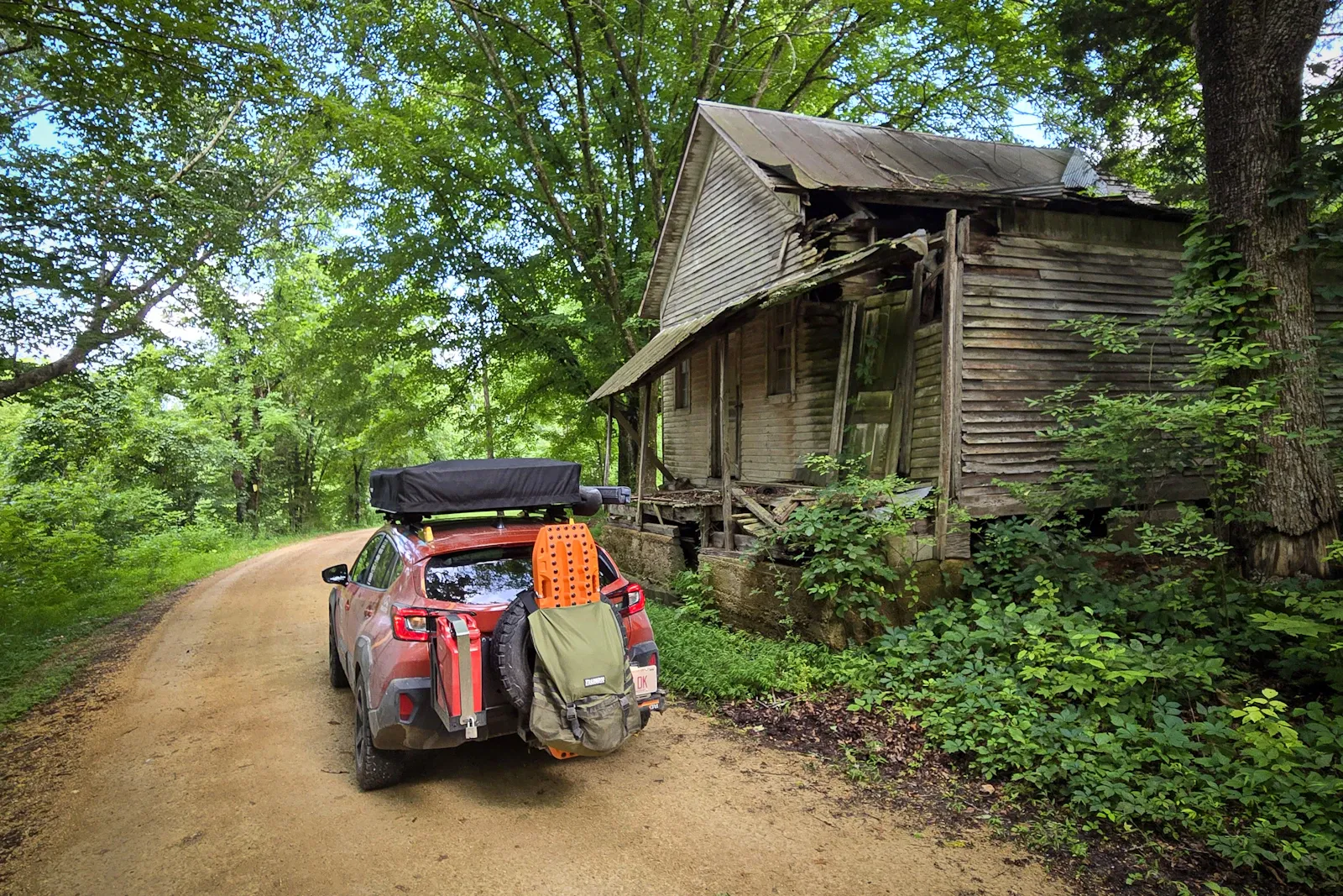
Once the storm system finally broke, we got our first real look at the central TAT. This is the part of the country that doesn't make the highlight reels. Tennessee farm roads, Mississippi two-track, Arkansas backcountry, Oklahoma red dirt. It is also, in our opinion, the soul of the trip.
Mississippi is the part we get asked about the most. The roads there turn into a slippery red clay when they get wet, and they get wet almost every afternoon in the summer. We crossed one hill that other travelers had clearly been stuck on for years — it was deeply rutted, slick as soap, and the locals had carved two bypass tracks around it that were almost worse. We aired down further, locked the differential via the X-MODE setting, and went up the original line. The Crosstrek's AWD system plus the KO2 sidewalls was exactly the right combination. We got up in one go. The Subie-bashing corners of the internet would have been proud.
The kudzu is something else. The TAT runs through stretches where the two-track is essentially a green tunnel, the vines hanging ten, fifteen feet off the ground on either side, swallowing the road and the air. It is a beautiful thing to drive through at fifteen miles an hour with the windows down. It is also, if you stop, instantly full of mosquitoes the size of your thumb.
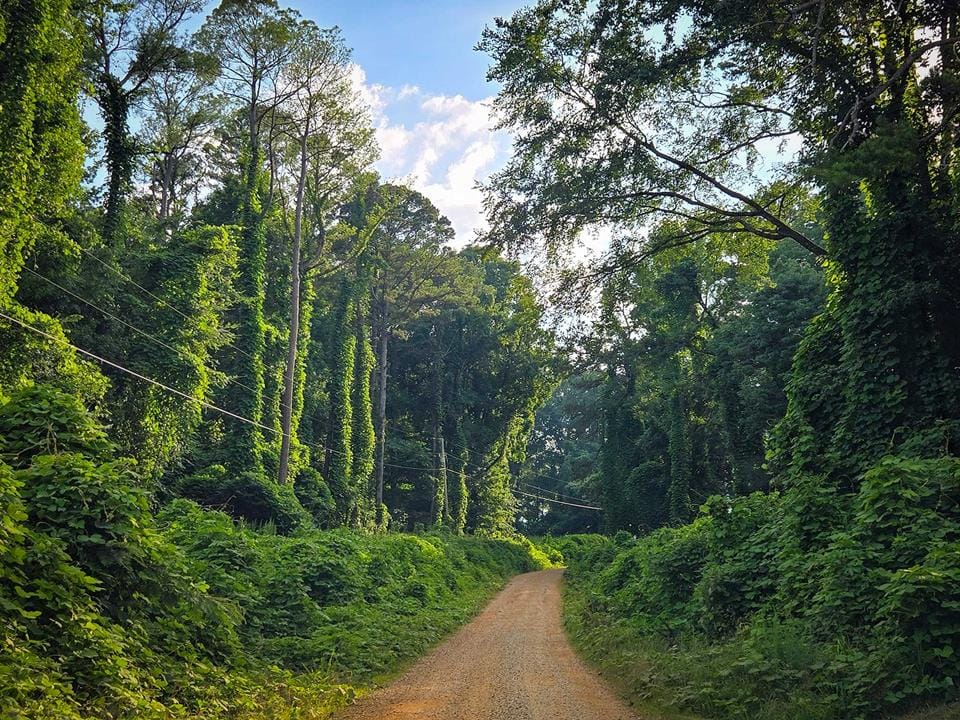
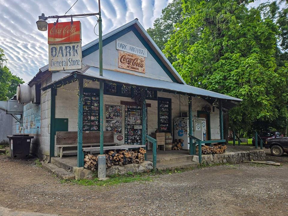
The single best stop on the central section was the Oark General Store in Arkansas. It is a small white building on a single-lane road, has been there since 1928, and serves a burger called the Oark Burger that is, genuinely, one of the best things we ate on the entire trip. We sat on the porch with two locals who had driven up from the river, ate fries out of a paper bag, and listened to them explain which roads were washed out. The store is on the TAT. If you do the TAT, you will end up here. You should plan to be hungry when you do.
Days 23–27: The Rockies
We knew the high country was coming. We had not fully understood what "high country" means in a non-turbocharged engine at nearly thirteen thousand feet of elevation.
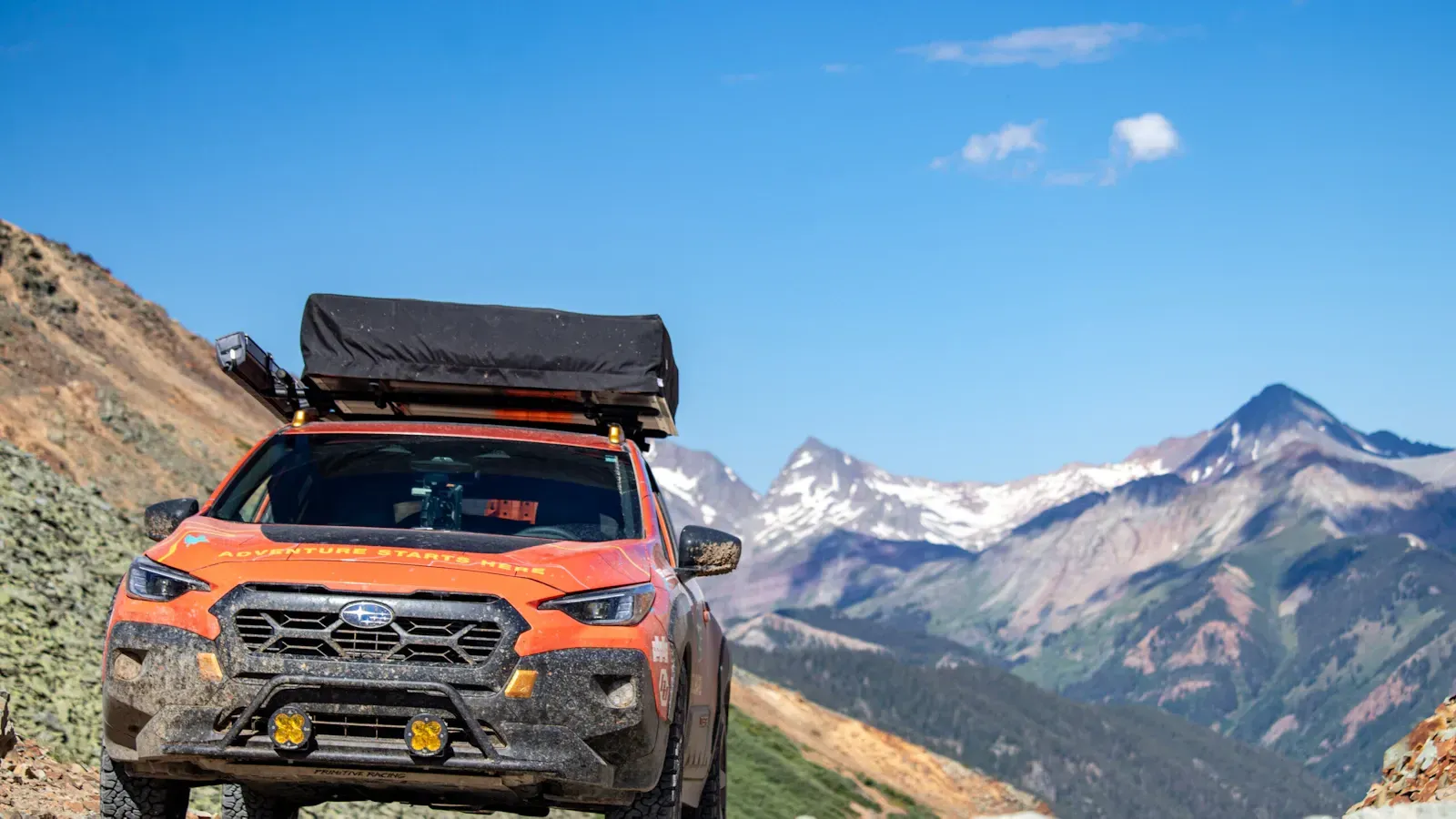
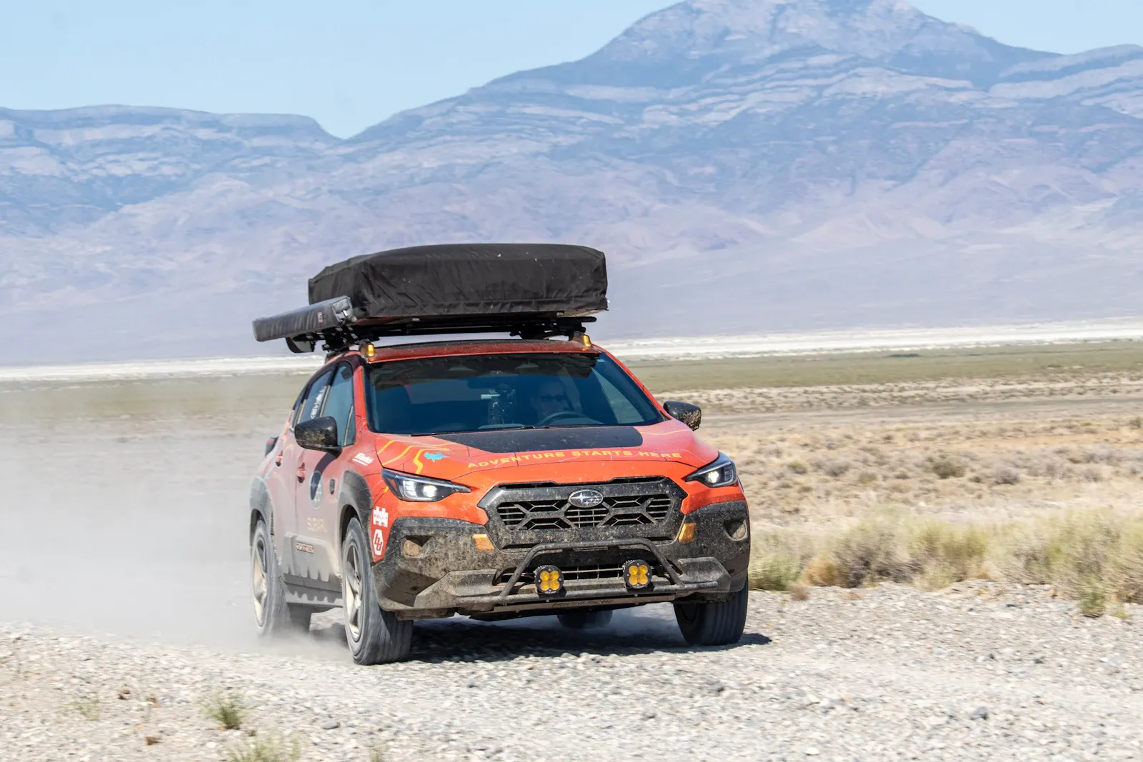
The San Juan Mountains in southwest Colorado are the kind of place that makes you remember why the West was slow to settle. The TAT runs over Cinnamon Pass at 12,640 feet and Ophir Pass at 11,790 feet, both shelf roads, both loose shale, both built on grades that would be illegal in a state with a functioning highway department. We cleared Cinnamon Pass without drama — the Crosstrek's 9.3 inches of clearance was enough, the KO2s were enough, and the AWD system was enough. At the top we ran into a local in a brand-new Toyota Tundra who looked at the Subaru with the expression of someone who had just been told a tax joke, and asked, "How'd you get that up here?" We had been the only Subaru at the summit. We saw plenty of them at lower elevations.
California Pass was the moment the trip almost won. It sits at 12,930 feet, and the easier bypass around it was blocked by feet of snow in early summer. The road to the top is graded, narrow, and has one short, very steep pitch near the summit. We hit the pitch at 12,500 feet in second gear, foot flat to the floor, and the Crosstrek did not accelerate. The non-turbo boxer four had run out of breath. There is no supercharger option for this engine. The CVT, designed for fuel economy on flat ground, could not generate the momentum the air was no longer providing. We slowed. We rolled backward. We turned around in a wide spot a hundred yards below the pitch and went back the way we came.
The trip was not over. We had to drive Cinnamon Pass again, in reverse, in afternoon sun, with the engine hotter than it had been all month, to reach Lake City for the night. There was no shame in it. There was no shame in it because the only vehicle that would have made that pass was one with a forced-induction engine and ground clearance we did not have. We were, by every reasonable measure, in the wrong vehicle for that exact line. And we had come within a hundred yards.
The lesson, the one we kept relearning, was that the TAT does not care what you are driving. It does not care if you have a winch and a snorkel and forty-five-inch tires. It will find the line that defeats you. The job is to know which lines to walk away from.
Ophir Pass we cleared without incident — not hard, but it'll quicken your pulse. A huge, narrow, cliff-side shelf road with loose shale, the kind of drive where the spouse in the passenger seat is making good use of the door handle.
We missed a 12.3-mile graded dirt road shown on onX maps. We drove 160 miles and three hours around the mountains to reach Silverton. We stopped at Flower Subaru in Montrose to fix a dented skid plate that was vibrating against a heat shield. The service writer came out to the parking lot, looked at the Crosstrek, and said the exact words: "You're the ones who did the TAT." The internet moves faster than the truck.
Days 28–29: Utah, Idaho, and the Coast
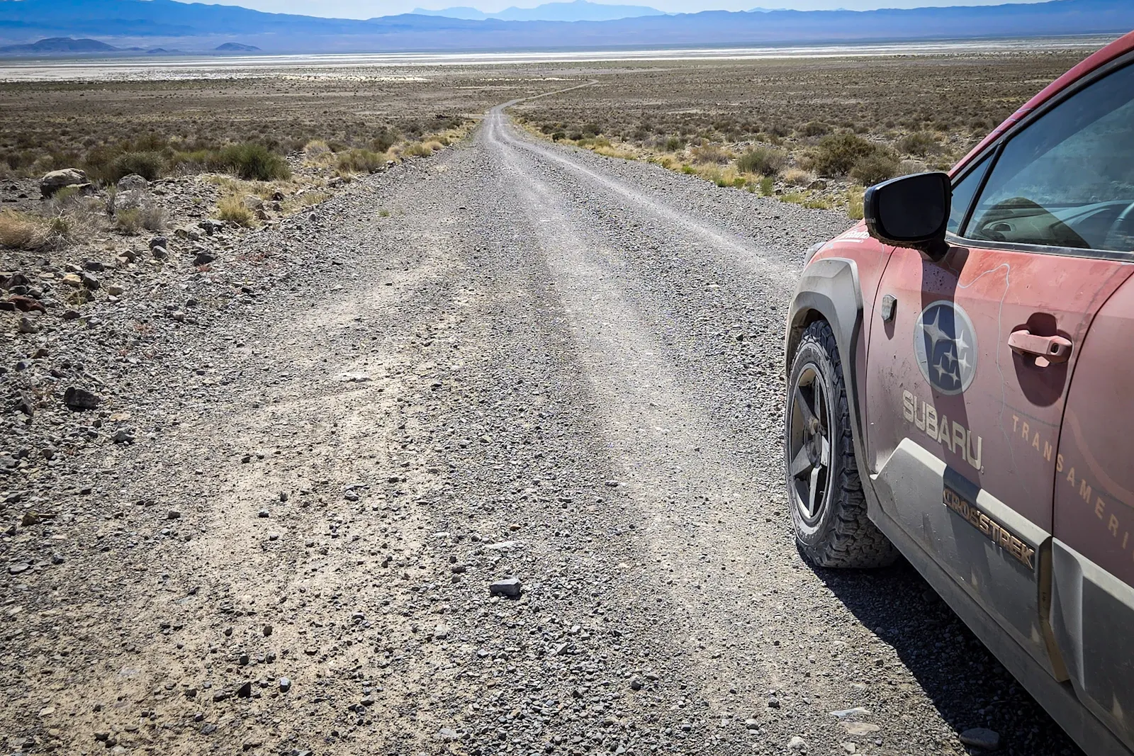
Moab hit 111°F the day we were there. We camped in the Sand Flats Recreation Area, which is a place that is approximately the surface of the sun for eight hours a day, and we drove Gemini Bridges and the San Rafael Swell The Dune, which looks like a set from Star Warsand which we will never forget. The temperature gauge in the car did not go below 110°F for the entire day. The fridge kept the water cold. The fridge is a hero.
The most important moment of the trip, and the one we have not told in public before, happened on a remote section of road near Wendover, Utah. We came around a bend and found a woman standing next to a small sedan with a flat tire and a dead phone. She had been living off-grid, her tire had gone flat, her cell service had been gone for two days, and she was crying. We had a tire plug kit, a 12-volt compressor, and a Starlink Mini. We plugged the tire, aired it up, charged her phone, and called her local tire company on the Starlink to confirm they had a replacement. We also charged her phone through the EcoFlow. She asked how she could ever pay us back. We told her the next time she saw someone broken down on a back road, to do the same thing. That is the deal. That is the only deal.
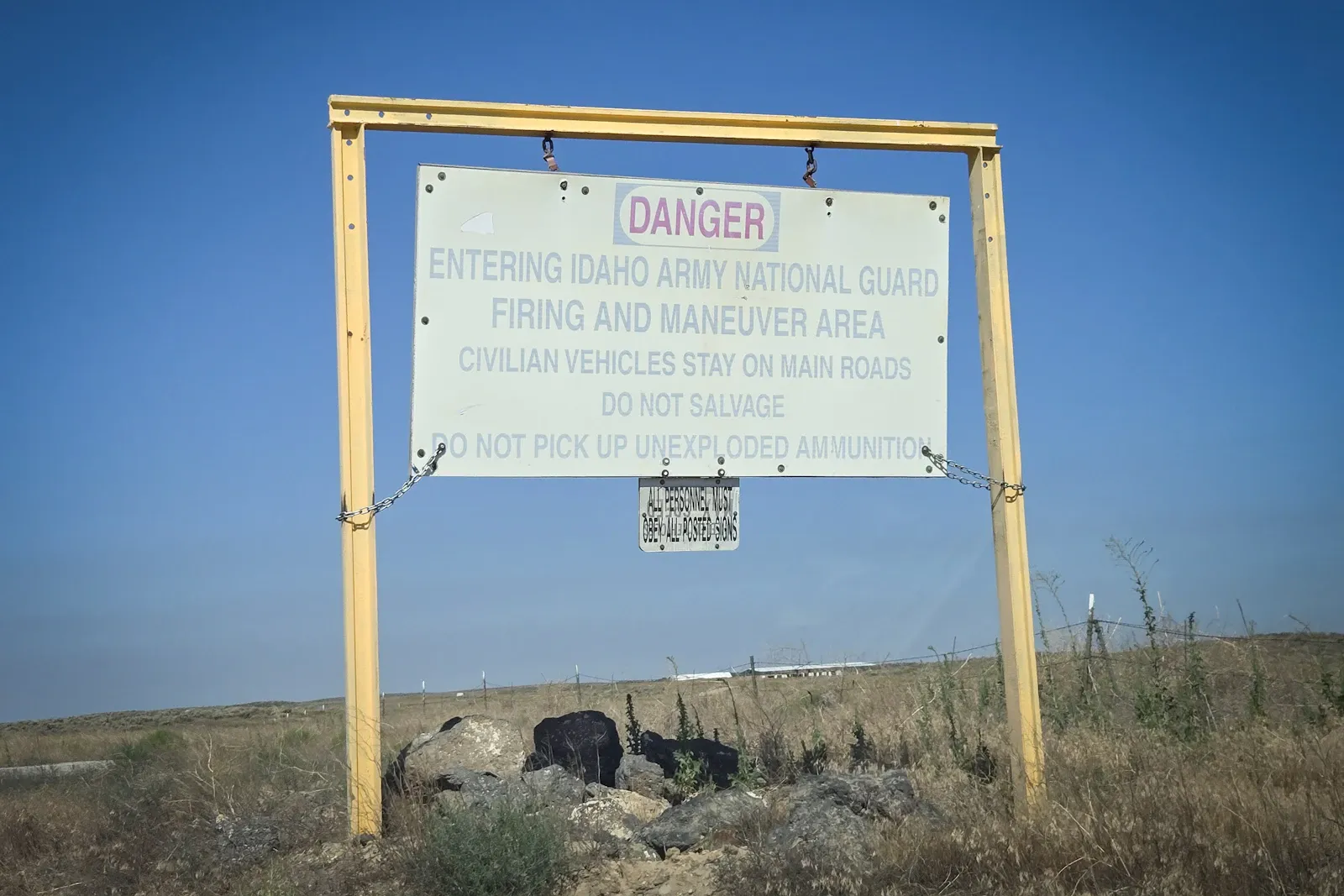
Idaho brought bombing-range dirt roads and the only dust of the trip that genuinely got into the cabin air filter. Then we crossed into Oregon, and the threats changed. We had spent the first month dodging storms. We now spent the final days dodging wildfires. The air quality app on our phones showed smoke readings that were, in some places, thirty times the safe allowance. We took more motel nights in Oregon than we had in the previous three states combined. We were not going to die of smoke inhalation on day 28.
The last day of the trip — day 29 — tried to break us. We were somewhere on NF-3353, in a steep section of national forest, when we came around a corner and found a six-foot-diameter sinkhole in the middle of the road. The forest service had not yet closed the road. They had not yet posted any warning. We would have driven into it at speed if Mercedes had not been watching the right side of the road at exactly the right moment. We rerouted via NF-5325, then Elk River Road, and reached the coast at Port Orford late in the afternoon, thirty-eight days after we had started planning and twenty-nine days after we had started driving.
We had fish and chips at The Crazy Norwegian in Port Orford. We drank champagne out of plastic cups in the parking lot overlooking the Pacific. We sat in the front seats of the Crosstrek and did not say anything for a long time.
The Numbers
| Stat | Value |
|---|---|
| Total distance | 7,163 miles |
| Unpaved surface | 3,184 miles |
| Days on the road | 29 |
| Average speed (overall) | 25 mph |
| Average driving hours per day | 11–12 hours |
| Longest day | 13 hours, 40 minutes |
| Route deviations | 39 (weather, flood, fire, sinkhole) |
| Days over 90°F | 28 of 29 |
| Days over 100°F | 6 |
| Trip high temperature | 111°F (Moab, UT) |
| Highest point reached | Cinnamon Pass, 12,640 ft |
| Highest point attempted | California Pass, ~12,500 ft (turned back) |
| Other TAT travelers seen | 0 |
What the Car Could and Couldn't Do
The Crosstrek Wilderness could: - Crawl over moderate rock gardens with steady throttle, no low range required, in Snow/Dirt X-MODE. - Air down to 18–22 psi and grip red clay, wet rock, and loose shale better than it had any right to. - Carry a month of food, water, and gear for two adults at 3,999 pounds, with 818 pounds of headroom. - Run an EcoFlow and Starlink off the alternator without straining the electrical system. - Cross river fords up to about two feet of moving water with the intake and battery protected by the skid plate package. - Drive eleven to thirteen hours a day, every day, for twenty-nine days, without a single mechanical failure.
The Crosstrek Wilderness could not: - Climb a steep 12,500-foot pitch in thin air with a non-turbo engine. We learned this the hard way. - Get unstuck from deep mud without aggressive throttle control. We learned to keep our momentum up. - Match a Wrangler Rubicon on technical lines. This is not what it is built for. We are not pretending it is. - Pretend to be a stock vehicle. The skid plates, the tires, the suspension, the lights, and the rack were non-negotiable. Without them, the trip would have been a short one.
The Three Things We Got Wrong
1. We trusted the high-altitude performance. A naturally aspirated engine at 12,500 feet has roughly 65% of its sea-level power. The math is easy. The reality is harder. We had assumed the CVT would help us; instead, it compounded the issue. We should have had a forced-induction backup plan for the high passes.
2. We packed more than we needed. The classic overlander mistake. Half the recovery gear never came out of the bag. The second spare fuel cell was dead weight for 4,000 miles. The medical kit, the size of a briefcase, could have been the size of a sandwich. We could have shaved two hundred pounds off the load.
3. We underestimated the dust. A full-face respirator would have been worth the cost and the weight. The cabin filter did its job, but the air inside the car for the first three hours of every driving day had a fine red haze. We should have run the fan on recirculate from the moment we started the engine, every day, no exceptions.
The Three Things We Got Right
1. We had redundant navigation. Garmin Tread running the GPX files, onX Offroad for real-time trail info, paper roll charts for the sections with no signal, and a real human navigator (Mercedes) who read the road ahead. No single point of failure. This was the single most important operational decision of the trip.
2. We had realistic expectations about the weather. The thirty-nine reroutes were not a sign of bad planning. They were the plan. We had budgeted two weeks of buffer. We used every day of it. The TAT in summer, in a non-stock vehicle, in this country, in this climate, is not the trip you wing.
3. We went with a partner we had done hard things with before. The 4,771 miles in the German-market ID. Buzz across nine Baltic countries, three Alcan 5000 rallies, four vehicles across the Nevada and California deserts — none of those trips were the TAT, but they were all the same trip in the way that matters. We knew how to communicate under stress, how to divide work, how to back off a bad line together, and how to laugh when the situation was already absurd. The TAT will not save a relationship that does not exist. The TAT will, however, show you exactly where the edges of your partnership are. It is better to learn this at 8,000 feet in Colorado than on the day you actually need the help.
The Slowest Way Across America
The TransAmerica Trail is not the smartest way to get to the Pacific Ocean. It is not the cheapest, the fastest, or the most comfortable. It is, however, the route where you can drive for an entire day without seeing another vehicle, where the only lights at night are stars, and where the small towns still have general stores with handwritten signs in the windows.
The Crosstrek Wilderness is not the right vehicle for everyone who wants to do this trip. It is, however, the right vehicle for the version of the trip that we wanted to do — the one that didn't require a second mortgage, the one that could be serviced at any Subaru dealer in the country, the one whose limitations we could learn around rather than overpower.
We never saw another TAT traveler the entire time. The trail, the route, the road — whatever you want to call it — is still there. It is mostly empty. It will not be empty forever. The longer you wait, the less of it will be the way it is right now.
We recommend you go.
Andy and Mercedes Lilienthal are overlanders, motorsport journalists, and the authors of the three-part OVR Magazine TAT series. They live in the United States and are slowly working their way through every named backroad on the continent. Photos by Mercedes Lilienthal unless otherwise noted. Vehicle provided by Subaru of America. Modifications and opinions are their own.